(DRAGONVILLE, VA)—Tommy Longest and his son-in-law, Kevin Norman, produce corn and no-till soybeans on about 4,000 acres (2,100 in corn) of land in King & Queen County, VA, between Dragon Run (the headwaters of the Piankatank River) and the Mattaponi River. They sell their grain to Perdue Farms, Inc. in Tappahannock and Mennell Milling’s Old Dominion Grain in West Point. Tommy, Kevin, and his wife, who is a nurse at a local hospital, also sell to grain broker Scoular Agricultural Service from the grain bin at their house on the Mattaponi. In 2015, they won a Clean Farm Award from the Virginia Department of Conservation & Recreation (DCR).
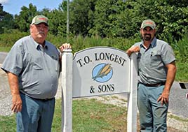
Tommy Longest, 64, has been on this land his whole life. Kevin Norman, 37, has worked there for twenty-two years, beginning while he was in high school.
Kevin Norman.
Tommy Longest, 64, has been on this land his whole life. Kevin Norman, 37, has worked there for twenty-two years, beginning while he was in high school. “Both of my grandfathers were farmers, so this is natural for me. Tommy and I mesh well,” Norman told us. “And we treat the land that we rent and sharecrop just like we do our own. In farming today, your reputation means everything.”
“NRCS has always been there to help us,” Norman continued. “Tommy introduced me. I’m out there doing the planting and farming as well as the technology side, so he let me take on the planning with them, especially in our EQIP and cover crop programs. They have a great crew here [in the Tappahannock Office]. They work with us. Once a year, Riverland Insurance has a dinner, and [U.S. Representative] Rob Wittman (R-VA01) comes by. The NRCS grants open windows to grab hold of the new practices, especially helping with the cost of equipment.”
Longest and Norman had had significant erosion problems with two-foot-deep ruts in the fields after a hard rain. No-till has helped a lot, with drain tile set deep in a few places, and strategically-located buffer strips to “make sure everything stays put. We don’t want ditches.”
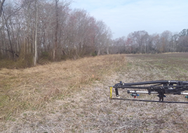
This buffer protects the pristine Dragon Run Swamp from farm runoff and is one of many farming practices adopted by Longest and Norman to protect the health of their farm and the waterways around it.
Kevin Norman.
Yield mapping has become particularly valuable, especially around wooded field edges that are shaded and “will never yield no how much we fertilize. We leave buffers there.” Longest and Norman keep their buffers growing for wildlife, though they bush-hog every three years. Several fields border the Dragon and the Mattaponi. “We live on the river. We want it clean.”
“We don’t irrigate at all, so soil health is critical,” Norman continued. “We need to make these fields very consistent, but we also make sure we don’t put too fertilizer much out there. The old soil maps are useful, but data we get from Climate FieldView offers updated soil maps that can overlay onto yield maps. That takes out a lot of the guesswork. It’s especially helpful when share-cropping to be able to track information precisely.
“Thanks to NRCS, we’ve planted cover crops for eight years, with mixtures of barley, winter wheat, tillage radishes (to break up hardpan), and crimson clover. They give us moist springtime seed beds to help seeds germinate. We’re adding [cover crop] acreage every year, over 1,000 acres now.
“FieldView helps us see if we need to analyze and prescribe fertilizer application on individual fields. We’ve been enrolling about 500 acres a year in Southern States’ precision ag program. It’s good for the environment AND the wallet, basing fertilizer application on soil needs, no more, no less. Our 2-3-acre grid samples are really important. Southern States can turn that information into a plan, supplemented by yield maps. These tools let us manage many things so much better. We send out tissue samples if we see threat signs through FieldView’s FieldHealth satellite imagery. We can adjust side-dress applications during the growing season, instead of guessing. New sprayers are SO accurate and fast, making nitrogen immediately available if the plants need it, with a firestick customized for our fields steering and controlling the speed of our sprayer. In five years, this will become the new standard for farming, giving us better bottom lines with lower input costs.
“I don’t think we would’ve had access to this technology without the Farm Bill conservation programs. If you can manage the soil better, it has a direct impact on your wallet. These federal and state programs produce a win-win. We are offered so many more opportunities for conservation than we were ten years ago. Technology makes our lives easier, our business more efficient; we can do our jobs better. For example, over the next several years, I can see drones with thermal imaging or a live feed helping us scout our fields during the growing seasons. With so much acreage, it’s too easy to miss patches under stress in field interiors.”
Longest and Norman definitely benefit from the teamwork offered by NRCS, DCR, and the local Three Rivers Soil & Water Conservation District. “We can’t wait to see what they offer next time,” said Norman. “They look outside the box to see what works on our land. It’s a great relationship. We’re dressing the land for the long haul. We love doing what we do.”


